Spatial Planning Tools
Science integration bridges the gap between research and practical application, working with partners to ensure that conservation planning and decision-making are grounded in the best available science. Through a collaborative approach, the NGPJV works to connect partners with data, tools, and technical resources that support effective, science-based conservation and natural resource management across the region.
The tools listed below are available to assist partners with project prioritization, monitoring (real-time data for adaptive management), and evaluation of conservation outcomes. NGPJV Science Integration Specialists, Krista Erdman (kerdman@ducks.org) and Tayler Scherr (tscherr@ducks.org), are available to provide guidance on tool use and to assist with project development, prioritization, and outcome assessment.
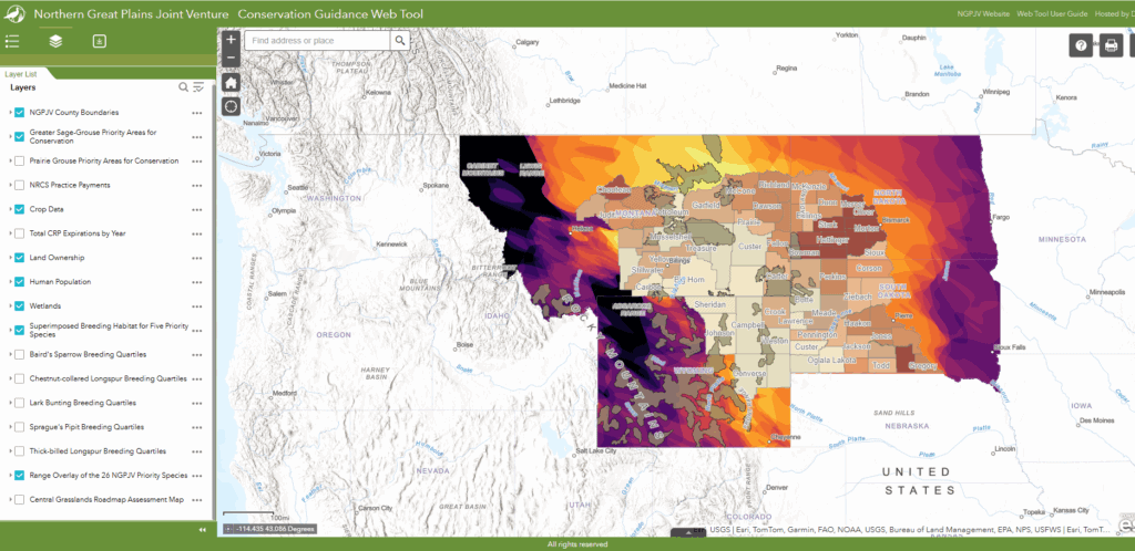
NGPJV Web Tool
The NGPJV developed a spatial planning web tool to help landowners and conservation practitioners better understand and visualize conservation opportunities and challenges. Our web tool focuses on spatial data that may not be easily accessible elsewhere, including priority species ranges, priority areas for conservation, and local project data. Please review the web tool user guide for more information on the tool and its data layers.
Additional Spatial Planning Tools
Tool Type | Resource Name | Host | Description |
Prioritization, Monitoring, Evaluation | USGS | A tool to explore and download data from UGSG's Earth Resources Observation and Science (EROS) archives, including Landsat Analysis Ready Data and National Agriculture Imager Program (NAIP) imagery. | |
Prioritization, Evaluation | Cornell University | A collaborative project that provides data on bird distribution, abundance, habitat use, and trends, collected by birders and citizen scientists from around the world. | |
Prioritization, Evaluation | US Fish and Wildlife Service | A hub to explore and download US grasslands and sagebrush data, including grassland bird core breeding habitats, SD Potentially Undisturbed Lands data, tillage and grasslands risk data, and North American Wetlands Conservation Act (NAWCA) priority areas. | |
Prioritization | US Department of Agriculture | An interactive map application that allows users to compare historical imagery from the 1950s with modern imagery from 2014-2023. | |
Prioritization, Evaluation | US Department of Agriculture | An agency that provides statistics that cover nearly every aspect of US agriculture, including production and supplies of food and fiber, prices paid and received by producers, and producer demographics. Statistics can be displayed at the state and county level. | |
Prioritization | World Wildlife Fund | A report that analyzes the rate of grassland plow-up in the Great Plains of the US and Canada, based on the USDA’s annual Cropland Data Layer and the Agriculture and Agri-Food Canada’s Annual Crop Inventory. | |
Prioritization, Monitoring, Evaluation | US Department of Agriculture | A tool that combines satellite imagery and on-the-ground measurements to visualize and analyze US vegetation data, including continuous vegetation cover, annual aboveground biomass, and 16-day aboveground biomass. | |
Prioritization | US Geological Survey | A tool to explore and download data, including National Hydrography Datasets, National Land Cover Database (NLCD) data, 3D Elevation Program elevation data, and NAIP imagery. | |
Prioritization, Monitoring | University of Nebraska Lincoln | A hub of drought data and resources that can be accessed at a national, state, or county level. Includes past and present drought severity, impacts of drought on agriculture, drought outlooks, and a suite of other data. | |
Prioritization | US Department of Agriculture | A tool that provides state and county level estimates of rangeland production lost to tree encroachment. | |
Prioritization, Monitoring, Evaluation | Nature4Climate | A tool that uses peer-reviewed data to demonstrate the emissions reduction potential for projects, alongside information on ecosystem and human benefits. |